Titan Geography
1. How the Powerful Tides Shape Titan's Overall Geography
Titan has two related tidal forces,
both resulting from its elliptical orbit around Saturn:
* the force that wants to change the shape of Titan, trying to pull it to more of an egg shape (tidal bulge) as it approaches Saturn and letting it relax towards rounder as it retreats form Saturn
* the libration force that pulls things eastward around periapsis and westward around apoapsis.
These two tidal forces acting together would appear to explain much of Titan's overall geography. Here's a chart showing the tidal forces on Titan as I see them.
The blue arrows show the maximum flow forces from libration: East then West all along the equator, still pretty strong at mid latitudes, then decreasing rapidly to zero at the north and south poles. (force = force at equator times cosine of latitude.) As viewed from Titan, Saturn is almost stationary in the sky, but it oscillates six degrees eastward and westward during the 384 hours of a Titan day. Flow force is maximum as the libration shifts fastest through 0 degrees in its circuit from -3 to +3 degrees longitude: periapsis and apoapsis. Midway, the flow forces come to a gradual halt and then reverse direction. Titan's overall tidal bulge is around 100 meters, and the libration forces wish to move this entire bulge east and west with Saturn's apparent librations.
The green arrows show the maximum flow forces due to the fact that Titan's tidal bulge wants to become more ellipsoidal, "egg shaped" as it approaches Saturn and more round as it retreats. In reality, the 45 degree arrows on the mercator projection represent flow between the 0,0 and 0,180 degree points and the 90/270 degree longitude circle in all directions. "Tidal bulge" flow forces are zero at these two "tidal poles" points and all along this "tidal equator" longitude, which includes the north and south poles. Flow force is maximum as the distance from Saturn changes most rapidly, part way between periapsis and apoapsis, and so the force is around 90 degrees out of phase from the libration flow force. The difference in tidal bulge between apoapsis and periapsis is around 9 meters, and these forces wish to change Titan's overall shape by this amount. While this might seem minor compared to the east-west 100 meter force, it is acting to move liquid (and air) back and forth over 90 degrees (º) instead of 6.
We might quantify the relative push from the two forces as 100m*6º=600 and 9m*90º=810. Obviously there is a lot more to it than that, but it leads to the supposition that one force isn't almost wholely predominant over the other.
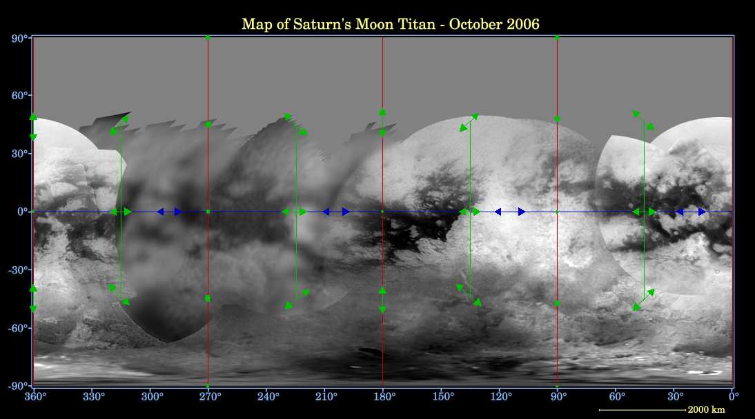
The first thing we note is that only one force can push liquid (or wind) north and south, and then only centered on two longitudes (0,180) and it's null at the equator and the poles, while both forces can push it east and west, and these forces are strongest at the equator, hence turbulent swampy seas and muddy flats wash east and west through the tropics (creating undersea "dunes" it would seem), while calm lakes and dry land predominate near the poles where both forces are null.
But these are approximations and the forces are not entirely symmetrical. For example, Titan is moving a bit faster at periapsis than at apoapsis, so the maximum "libration forces" are strongest at periapsis as the Saturn and Anti-Saturn poles are at high tide and weaker at apoapsis when they are at low tide.
At 90 and 270º longitude (the "tidal equator"), the tidal bulge flow forces are null, and at the equator they are also null at the "tidal poles", 0º and 180º. Tides here may rise and fall, but the liquid doesn't flow (from the egg-shaping forces). In between these points at the equator, the bulge flow forces are maximum. Thus, in four areas, there is just the libration force shoving things east and west, but in the four areas in between, there are both forces, about 90º out of phase, shoving things east and west.
Now we get back to the seas and the chart. If the two tidal forces are not too dissimilar in strength, we might expect to find four "collection basins" - seas - where there is only one flow force (0, 90, 180 and 270º). Because the liquid has less overall force pushing it east and west there, it accumulates from the areas where it is being pushed back and forth more strongly. With the weight of liquid, these areas should tend to become depressions. In the in between areas (45, 135, 225 and 315º), the liquid is being pushed harder most of the time (and at a somewhat different time - out of phase). There we might expect to see expect more river-like formations: channels that run between the basins.
I don't think it would be too far amiss to say that's approximately what the map shows, given that Titan is a real world and not just a perfect theoretical model, except everything - the seas and channels - is displaced a little to the east of where it's expected, by maybe 20 degrees. This would seem to result from the libration force flowing eastward at periapsis being stronger than the westward force at apoapsis. [Note: See Titan Rotation" in the footnotes of the title page].
Looking at the left 3/4 of the chart, the tropical area does in fact look very much like the model: sea-channels-sea-channels-sea. Other land shaping factors may alter the reality from the theoretical model: The expected sea at 70 degrees appears to have run well north of the equator, it doesn't seem to have any channels to the antipodal ("160 degrees") sea, and while the channelled nature of "the H" is not entirely lacking, it is more in the nature of continuous seas through to the sub-Saturn ("340 degrees") sea. Perhaps there was harder rock in the way in the bright Xanadu area at 120 longitude, preventing erosion, so the liquid had to find other courses. The two seas have the appearance of trying their best, north of the equator, to work their way past that 120 degrees longitude blockage, and there may even be some narrow channels we aren't seeing.
The arctic lakes might extend southwards farthest near the 90/270 degrees longitude circle, but again they may be found to be displaced eastwards by perhaps 20 degrees, to 70/250 degrees, unless other factors prevail. (We may have to wait for a polar map(s) to get a good visual on this.)
* the force that wants to change the shape of Titan, trying to pull it to more of an egg shape (tidal bulge) as it approaches Saturn and letting it relax towards rounder as it retreats form Saturn
* the libration force that pulls things eastward around periapsis and westward around apoapsis.
These two tidal forces acting together would appear to explain much of Titan's overall geography. Here's a chart showing the tidal forces on Titan as I see them.
The blue arrows show the maximum flow forces from libration: East then West all along the equator, still pretty strong at mid latitudes, then decreasing rapidly to zero at the north and south poles. (force = force at equator times cosine of latitude.) As viewed from Titan, Saturn is almost stationary in the sky, but it oscillates six degrees eastward and westward during the 384 hours of a Titan day. Flow force is maximum as the libration shifts fastest through 0 degrees in its circuit from -3 to +3 degrees longitude: periapsis and apoapsis. Midway, the flow forces come to a gradual halt and then reverse direction. Titan's overall tidal bulge is around 100 meters, and the libration forces wish to move this entire bulge east and west with Saturn's apparent librations.
The green arrows show the maximum flow forces due to the fact that Titan's tidal bulge wants to become more ellipsoidal, "egg shaped" as it approaches Saturn and more round as it retreats. In reality, the 45 degree arrows on the mercator projection represent flow between the 0,0 and 0,180 degree points and the 90/270 degree longitude circle in all directions. "Tidal bulge" flow forces are zero at these two "tidal poles" points and all along this "tidal equator" longitude, which includes the north and south poles. Flow force is maximum as the distance from Saturn changes most rapidly, part way between periapsis and apoapsis, and so the force is around 90 degrees out of phase from the libration flow force. The difference in tidal bulge between apoapsis and periapsis is around 9 meters, and these forces wish to change Titan's overall shape by this amount. While this might seem minor compared to the east-west 100 meter force, it is acting to move liquid (and air) back and forth over 90 degrees (º) instead of 6.
We might quantify the relative push from the two forces as 100m*6º=600 and 9m*90º=810. Obviously there is a lot more to it than that, but it leads to the supposition that one force isn't almost wholely predominant over the other.
The first thing we note is that only one force can push liquid (or wind) north and south, and then only centered on two longitudes (0,180) and it's null at the equator and the poles, while both forces can push it east and west, and these forces are strongest at the equator, hence turbulent swampy seas and muddy flats wash east and west through the tropics (creating undersea "dunes" it would seem), while calm lakes and dry land predominate near the poles where both forces are null.
But these are approximations and the forces are not entirely symmetrical. For example, Titan is moving a bit faster at periapsis than at apoapsis, so the maximum "libration forces" are strongest at periapsis as the Saturn and Anti-Saturn poles are at high tide and weaker at apoapsis when they are at low tide.
At 90 and 270º longitude (the "tidal equator"), the tidal bulge flow forces are null, and at the equator they are also null at the "tidal poles", 0º and 180º. Tides here may rise and fall, but the liquid doesn't flow (from the egg-shaping forces). In between these points at the equator, the bulge flow forces are maximum. Thus, in four areas, there is just the libration force shoving things east and west, but in the four areas in between, there are both forces, about 90º out of phase, shoving things east and west.
Now we get back to the seas and the chart. If the two tidal forces are not too dissimilar in strength, we might expect to find four "collection basins" - seas - where there is only one flow force (0, 90, 180 and 270º). Because the liquid has less overall force pushing it east and west there, it accumulates from the areas where it is being pushed back and forth more strongly. With the weight of liquid, these areas should tend to become depressions. In the in between areas (45, 135, 225 and 315º), the liquid is being pushed harder most of the time (and at a somewhat different time - out of phase). There we might expect to see expect more river-like formations: channels that run between the basins.
I don't think it would be too far amiss to say that's approximately what the map shows, given that Titan is a real world and not just a perfect theoretical model, except everything - the seas and channels - is displaced a little to the east of where it's expected, by maybe 20 degrees. This would seem to result from the libration force flowing eastward at periapsis being stronger than the westward force at apoapsis. [Note: See Titan Rotation" in the footnotes of the title page].
Looking at the left 3/4 of the chart, the tropical area does in fact look very much like the model: sea-channels-sea-channels-sea. Other land shaping factors may alter the reality from the theoretical model: The expected sea at 70 degrees appears to have run well north of the equator, it doesn't seem to have any channels to the antipodal ("160 degrees") sea, and while the channelled nature of "the H" is not entirely lacking, it is more in the nature of continuous seas through to the sub-Saturn ("340 degrees") sea. Perhaps there was harder rock in the way in the bright Xanadu area at 120 longitude, preventing erosion, so the liquid had to find other courses. The two seas have the appearance of trying their best, north of the equator, to work their way past that 120 degrees longitude blockage, and there may even be some narrow channels we aren't seeing.
The arctic lakes might extend southwards farthest near the 90/270 degrees longitude circle, but again they may be found to be displaced eastwards by perhaps 20 degrees, to 70/250 degrees, unless other factors prevail. (We may have to wait for a polar map(s) to get a good visual on this.)
April 13th 2007. Previous chapter with earlier ideas deleted.