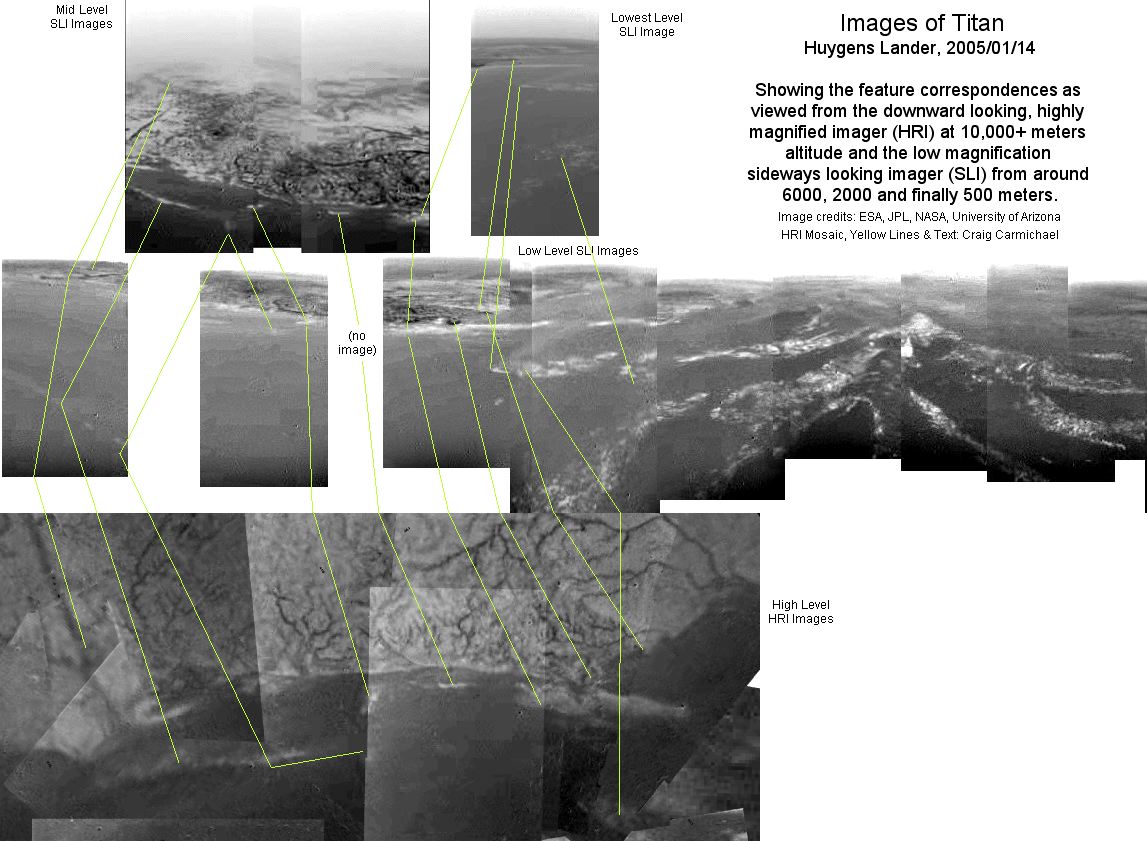
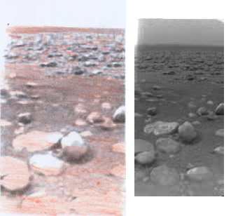
Living Titan Index
Titan's Calm Arctic Lakes and Turbulent Tropical Seas

On Earth we have oceans of liquid water - H2O. It covers around 70% of our globe. On Titan the surface temperature (~92 to 94°K) is such that water - ice - is just another kind of rock. Instead, there are seas of liquid methane - CH4, having waves and tides. There also seem to be lakes in the arctic and antarctic regions. The seas appear to connect via tidal flow channels and ring the equatorial region with just one gap, but there are no huge deep oceans similar to Earth's. At Titan's quite stable temperatures of about 94ºK, Titan's seas are only about 3º above methane's freezing point, but they are also closer to boiling than Earth's waters, and so Titan's air in the troposphere is about 3 to 5% methane vapor. The Huygens lander seemed to have encountered drizzly rain, half inch long drops of methane slowly falling from the sky.

The liquid methane seems quite clear and transparent. In fact, it can be deceptively difficult to realize Huygens was looking into or through liquid and not just air in some situations. This situation can also apply to water on Earth, especially in downward looking monochrome images. This would seem to be another reason the space scientists didn't see it, along with the sometimes grotesque contrast magnification in the supposedly unprocessed images. (Other viewers of the after landing images did see the shallow liquid - at least until the space scientists told them it wasn't real.) Methane has certain light wavelengths in the camera's range which would be absorbed in a few meters or even centimeters, but others that are highly transparent.

Somehow space scientists expected any liquid methane to look dark. The reason it seems much more transparent than its absorption spectrum would suggest is that Titan's atmosphere, 4.5 x more dense than Earth's air and extending much higher, contains several percent methane vapour, so daylight at Titan's surface has already been filtered to methane transparent wavelengths that can easily penetrate the sea. This is evident in Cassini visual images of Titan taken with different wavelength filters: only the methane transparent wavelengths get through to show the surface.

A few centimeters, perhaps even tens or hundreds of meters, of liquid is little beside the 700000 meters of increasingly thick methane vapour the light has already passed through. The safest things that can be said are that very shallow liquid will hardly dim the view, and that deeper liquid should look darker than shallower liquid. The amount is difficult to quantify, especially as we don't know how dirty or clear the liquid is. In some of the Huygens images it's evident we are looking into at least tens of meters, often (as seen on the SAR radar) up to 400 or more meters, of liquid and seeing the sea floor quite well. Likewise, in an Apollo 8 Earth image from 3500 miles distance, shallow banks off the Bahamas are clearly visible under the sea.

Space scientists seem to have clung on to their preconceptions of what Titan might be like from before the mission. They expected to find seas of "methane and ethane". There is only methane vapor in the atmosphere. Of course there could be trace amounts of ethane, but on landing, the Huygens CGMS team reported finding "relatively pure liquid methane on the surface." (More on that elsewhere.) The rest of the scientists are still talking about bodies of "methane and ethane". If there is any actual evidence for ethane it was never disclosed to the public. This is not the only instance of ignoring actual evidence in favor of continuing to hold prior beliefs or theories.


Titan viewed from about the direction of Saturn, light filtered at 938 nanometers (in the near infra-red).
This frequency was doubtless chosen because it is the center of the light band where methane is the most transparent, hence it provides the clearest view of Titan's surface. While Titan's atmosphere has a hydrocarbon particle haze, the methane vapor in the atmosphere appears to be the main factor limiting visibility. But it is mainly the fact that so many things in the "dark areas" - seas - are actually submerged, and that the landscape is so different from anything in our experience or expectations, that creates the perceived "poor viewing conditions". And, one simply cannot describe what is seen on Titan without recognizing the visual effects of plant life.


Methane absorption Spectrum and Huygens camera imagers wavelength sensitivity. (Grundy warns the measurements shown for the more transparent - and hence more interesting here - bands were subject to much measurement error and uncertainty.) Notice the most transparent band, about 938 nanometers, is the filter Cassini uses for most images of Titan. Between the transparent bands, Titan's surface can't be seen from space, indicating that little or even no light of those wavelengths reaches the surface.
http://www.lowell.edu/users/grundy/CH4ice.html

Water (H2O) is very transparent only around the visible spectrum, around 400 to 700 nano-meters. We didn't just luck out: our eyes evolved sensitive to those wavelengths because we'd have trouble seeing at others (especially underwater). On Titan, eyes would evolve sensitive in methane passbands and "Titanians", if they should exist, would have a somewhat different sense of colors than Earth people.

Huygens' downward looking reflectance spectrum from 21 meters altitude (with the broad spectrum floodlamp on) essentially matches the methane spectrum above, showing that the surface at or near the landing point was essentially liquid methane. Once on the surface, a rather different spectrum was measured, but on the ground the downward looking spectrometers could have been looking at any random single object, much as the MRI and HRI imagers largely did. (Perhaps even that same object, but I haven't studied the exact locations of the instrument lenses.) (These spectra were published in NATURE Journal, 8 Dec 2005: Rain, winds and haze during the Huygens probe’s descent to Titan’s surface, M. G. Tomasko et al: http://www.nature.com/nature/focus/huygens/index.html)


Liquid Methane on Cassini RADAR

The transparency of the methane seems to extend also to the RADAR imaging by Cassini. Methane being a non polar, non conducting liquid (unlike water), the energy of the pulse isn't shorted out at the surface, and so it travels through the liquid, even to hundreds of meters depth - but darker and darker with increasing depth. Thus, what Cassini sees in submerged areas, are the features in the liquid and on the bottom, but darker than in non submerged areas.

Probably there are gradual losses of the signal as it travels through the liquid, and the deeper the methane the darker the view. But this is complicated by the fact that waves on the surface can cause surface reflections back to Cassini. The calmer the 'waters', the less of the surface and the more of the bottom should be seen.


A lake in the high arctic region. Terrain and features are seen on radar right through the methane liquid, but appear substantially darker with depth. The vertical stripes would appear to be imaging scan lines rather than actual features.


Cassini T14 Radio Occultation & Bistatic Scattering Experiment

   On its 14th flyby of Titan (among others), Cassini got behind Titan from Earth. Where it hit the correct angles coming and going, radio waves were bounced off Titan's surface and received by a Deep Space Network antenna on Earth. T14 hit those angles at low latitudes, where the dark, evidently liquid sea, areas are found. The team responsible reported readings consistent with liquid hydrocarbons in repeating intermittent patches, with "very rough terrain" in between.
   This was early in the mission, and the undersea dunes had not been discovered. The team theorized: "Lakes?" What seems only too evident now was that Cassini's radio ground track went across the undersea dunes. Liquid was sensed in the dune troughs, but at the crests profuse aquatic vegetation ("very rough terrain") got in the way - just as it blocked the glare of "spectral reflections" off the surface of the liquid and led other teams to ignore their own eyes and conclude that what looked like seas must be dry.


SOURCE of the METHANE


We know that methane has been identified in the spectrum of very cold bodies such as Pluto and Triton, which would be frozen methane. So it is probably a natural ingredient, present in the solar nebula which spawned the worlds. Closer to the sun, it would quickly boil off and decompose. Methane, with a density 0.8 times that of water, may also play a role in the unexpectedly low density of some outer solar system bodies, such as Saturn's asteroid Hyperion, which has about that density. But even on Earth methane is present as "natural gas", underground and underwater.

A continuing question about Titan has been that since methane is converted into other compounds eventually by the energy of UV sunlight, why should Titan still have any in its atmosphere? I've been thinking that life may replenish it. On Earth we burn sugars and oxygen to make carbon dioxide. Only the plants keep the oxygen level high and the carbon dioxide level trivial. On Titan plants might well convert methane to hydrogen and carbon, while animal life would burn sugars and hydrogen, producing methane.

Now there is a new theory (Feb-March 2006) that methane is locked up underground on Titan, trapped within water ice as methane clathrate hydrate (as on Earth), and has been released to the surface at three eras during Titan's history. So instead of having to persist all these eons since Titan formed, some methane has only been released to the surface and exposure to sunlight much more recently.

http://www.space.com/scienceastronomy/060301_titan_methane_ocean.html
http://www.spaceflightnow.com/cassini/060301methane.html

The idea sounds reasonable and would solve the puzzle. The only comment I can add here is the idea that if life has spread over Titan, its biological processes will probably keep the methane from slowly vanishing.


WAVES, SPRAYS and FROTH

It has been estimated by some that Titan's air pressure of 1460 millibars, and its lower gravity (1/7 of Earth's) would result in huge, slow moving and possibly frothy waves even at relatively low wind speeds. Instruments on the probe detected light winds of up to about 15 mph at the surface, but generally less at 5 Km per hour. Waves and spray are in evidence in various Huygens images, though the spray, and perhaps the waves too, seem to result mainly from tidal flow.


Waves and spray are raised in the low gravity where the tidal flow meets underwater obstacles.
The idea that the landscape is a changing seascape seems illustrated by the difference in views of the same areas in the Huygens images. In some images, waves striking obstacles on or near the sea surface appear to raise bright spray or whitecaps in the low gravity, while in others, the same area appears dullish grey in an apparent lull between waves:


TIDES

Titan's powerful tides are caused by the eccentricity of its orbit. When Titan is farther from Saturn, it is more round, and when closer, it is more stretched, the long axis pointing at Saturn. This tidal bulging is well illustrated by Saturn's rings and smaller moons: The rings are within the Roche limit, the zone of critical tidal disruption, and would be either a moon that never formed, or one than got too close to Saturn and was pulled apart by tidal forces, much as comet Shoemaker-Levy 9 was pulled apart by flying too close to Jupiter. Janus and Epimethius, orbiting at the outer edge of the limit, are very egg shaped, and each small moon farther out is more round than the previous one in. Titan is much farther from Saturn, but it has an average bulge of about 100 meters. The orbital eccentricity causes a change of 9%, or 9 meters, between periapsis and apoapsis. Since Titan orbits Saturn once every 16 Earth days, a Titanian day is about that long, and the tide goes in and out again just once in that period. The time of day of the tide would change by area, and with the seasons of the year as Saturn orbits the Sun.

Visualizing an ocean covered world, at the point (always) facing Saturn (0 degrees longitude, at the equator), and at the antipodal (opposite) equatorial point away from Saturn, the sea levels change most (the nine meters figure applies) as Titan wishes to become more and less like an egg. Midway around the circumference, that is to say along the entire longitude lines of 90 degrees and 270 degrees, the levels vary opposite to the Saturn/anti-Saturn nodes. At these areas also, if there were no land in the way, the horizontal tidal flow would be zero. At two circles somewhere in between the 90/270 circumference and the Saturn and anti-Saturn points, the sea level wouldn't change, but the tidal current flow between the 90/270 circumference and the Saturn or anti-Saturn point is maximum.


A second tidal force occasioned by Titan's eliptical orbit is the "libration force". Like Earth's moon, Titan has the appearance of wobbling back and forth. It is the orbit, Titan speeding up near Saturn and slowing down as it moves away, that changes the relative facings: Titan's rotation stays constant. Over an orbit, Saturn appears to move 6 degrees eastward, then come back again, 3 degrees on each side of zero longitude. As it does so, it attracts the air and the liquid: the 100 meter bulge wants to follow Saturn back and forth. In the equatorial zone, and decreasingly with the cosine of the latitude, the seas and the air are pulled clockwise and counterclockwise in a repeating cycle that is out of phase, by about 90º, to the "egg shaping" forces.


It is probable that Titan deforms internally to some extent with the varying tidal forces. I have no figures for this, but if, for example, this internal deformation is 4.5 meters, then the tides in the liquid would be acting from 4.5 meter variances instead of 9 meters. When we consider that the tidal forces on Earth operate from a variance of around half a meter, we are left to conclude that in spite of Titan's low gravity, any internal flex Titan has, and the long tidal period, its tides must be very spectacular!

Oceans don't seem to dominate Titan's surface as they do on Earth. But the equatorial seas almost ring the planet, so the tides will surge strongly eastward and westward - and more strongly eastward, when Titan is closer to Saturn. The westward flow is more diffuse, acting more gently over a longer period of time when Titan is farther from Saturn. There are in fact major sea areas visible at about 0, 90, 180 and 270 degrees longitude, with channels joining them all. This flow drags sediment with it, creating underwater dunes forming various shallows, sand bars, tidal flats, islands and the like in the areas in and around the equatorial seas. This powerful tidal flow defines the geography of the channels and the seas connected by them. Sediment has been dragged into the equatorial regions to the extent that they are raised a kilometer above average polar elevations, and the eastward flows of sediment evidently cause Titan's long axis to continually shift, resulting in a revolution of Titan with respect to Saturn about once every 1000 Earth years. For a more detailed explanation of how this seems to work, please see "How the Tides Shape Titan's Overall Geography" in Chapter 3.

   Additional evidence that the dunes are underwater is that according to SAR radar data they are perfectly level for hundreds of kilometers: no dune crests stick up any higher than the rest. The troughs look much darker to the radar which makes sense as they are submerged by around 400 meters.
   (Space scientists somehow still thinking the dunes are in air say the troughs are made of darker material than the crests. Huh? They also don't understand how there's enough wind to form them. Tidal liquid flow is the obvious explanation.)


The north-south flow through the gaps between the seas in the region above is especially interesting: the liquid is pulled to the right as Titan approaches Saturn and thence it flows from the North Saturn facing sea mainly through the eastern channels into the more easterly main area of the South Saturn sea. The eastern channels thus have what appears to be a shallow silt delta at the south end. (Equatorial 0º longitude directly facing Saturn is just east of this delta) As Titan retreats from Saturn again, the regional flow is westward, and thence from the south sea into the north (which ends at about 90º west longitude) more through the western channel, causing a delta at the north end of that channel. This establishes a circular circulation pattern between the two seas.


Titan Surface Map.
Zeroº longitude faces Saturn, while 180º is the antipode. Huygens, landing at the west end of the antipodal sea, seems to have seen very strong tidal flows through the narrow channels leading to the east towards the 180º point, which matches expectations for the time of landing. An interesting question is whether the sea to the left (~270º longitude) becomes noticeably deeper, and hence darker and with less islands, while Huygens' antipodal sea becomes shallower and hence lighter and with more islands, vice versa, at the right times of the tides. If this result of the tides is visible from space, such observations would give the Cassini another independent confirmation that Titan's seas are indeed liquid.


This Cassini VIMS and RADAR combined image of the crater(?) at 20 degrees west shows what appear to be deeper, or at least darker, "tidal flow lanes". The ones going south are just north of the eastern delta. (Could this be an elusive cryovolcano?)


ATMOSPHERIC TIDES

The same tidal forces at work in the seas also affect Titan's thick atmosphere, causing it to flow back and forth between the Saturn/anti-Saturn points and the 90-270 degree longitude line. As described for the seas, this should result in regular zonal winds between these areas, independent of any other causes of winds. How much the anemometer changes at the Saturn facing point, I won't venture to say but someone has probably worked it out somewhere!


Huygens' Landing Site


A later composite mosaic "fish eye" view of the Huygens descent images by JPL/NASA.
In a sea of dunes filled with prolific aquatic vegetation, it is questionable whether
anything but leaves and stems actually protrudes above the liquid's surface.

In the darker center area there appears to be a smear of material flowing from lower left to upper right.


Titan's Surface from the Huygens lander
I took six of the after landing images, enlarged and combined them.
There are enough differeneces between frames to render the
view more clearly than in any individual low-rez image.


I colorized the sharpened image. Overall brightness of each pixel remains the same.
(Eg, +8 red, -4 green, -4 blue makes it redder)
Of course I have no idea of the actual colors. I intend the color contrast simply to help
point out features that are vague and scarcely distinguishable when all is shades of gray.
The 8x8 pixel compression artifacts are clearly visible, but also are quite distinguishable from the actual image features


When it separated from the Cassini spacecraft three weeks before it reached Titan, Huygens was aimed at what looked like a coastline from space. (In fact, it descended over a duney liquid area and touched down on top of a small dune crest only inches below level with the sea surface.) In addition, Huygens was cleverly engineered to rotate slowly under its parachute as it descended, to capture images that could be built into 360 degree views with fixed-position cameras. While many things are hazy or otherwise unclear, both "land" (dune crests) and sea areas are visible in this first higher altitude mosaic:


There are a number of points showing that Huygens descended over a liquid sea and not a dry "playa" as was so hastily assumed. In many images there appear to be waves, reflections and even faint clouds of spray that are inconsistent with a dry surface. A parabolic arc of spray is seen in SLI-698. The SLI images over the sea look darker towards the bottom. This would be because looking across liquid one sees the surface reflections while at a steeper angle, beyond the critical angle of total internal reflection, one is looking down into the darker liquid (for methane the angle is 52º - water is 48º). Waves and other probable factors prevent this angle from being clearly defined. (At one point I thought the MRI images were even better examples: there is a well defined bright area near the top of each. However, the view angle, about 45º, is wrong, and the brightness appears to occupy the same pixel positions in each image, so it must instead be an aberration of the camera optics - probably frozen methane dew on the lens.) Another telling point is that except at the specific much brighter "mud flats" points, the SLI images look more and more like flat, featureless liquid as the surface approaches, instead of revealing more and more small landscape details. What few details are seen look murky - submerged. (Unfortunately some early images shown on the web and misrepresented as being the "raw images", were grotesquely contrast magnified, obscuring the entire nature of the scenes shown.)

Huygens' small parachute allowed it to fall fairly fast in order that it reach the ground before the Cassini was out of radio range. But instead of being destroyed by the impact as had been surmised would happen if it hit hard ground, Huygens landed very gently with a "splat" ("a creme brulee soft landing"), viewing what appears in the images to be two or three inches of methane, a few feet off the leeward edge of a surface having features rising just above the 'water'line. It looks diagonally across this 'shoal' to an area having deeper liquid. Liquid was not sensed by the Surface Science Package instruments, but this contradicts the GCMS finding of "liquid methane on the surface." To me, some of the SSP instrument readings from the surface, as far as this amateur was able to interpret the raw data, just didn't add up for any kind of landing, dry or wet. Visually in a number of descent images, the tide appears to have been running strongly and it would seem the rushing sound was picked up by the microphone as long as the transmission continued, though strong internal mic noise and strange sound recording techniques complicate the interpretation of what is being heard.

ESA scientists noted that Huygens' radio signal strength as received by Cassini after the landing varied in a regular rise and fall pattern and deduced that this must have been caused by reflections of the radio waves from the surface. What but waves on liquid might account for this cyclic result?


Huygens's Landing Point ("X") (New July 2006 rendition) - Mosaic by Craig Carmichael
(Note: Transparency is Off, so features appearing to cross image boundaries actually do.
Patterns created by wave crests may vary between images.)

Click this image for the larger view to see the broad area context of this cropped view.
Images from Huygen Raw Images - HRI;  scaled from "ImageAltitudes.txt"; Orientations as shown.


Until now (March 2006) it has been assumed that Huygens landed "on the dark terrain" - presumably sea - and yet in spite of the "creme brulee" soft landing, it wasn't floating. But it appears instead that it actually landed on one of the many small bright mud or silt bar [dune peak] "island" areas, apparently just a couple or three inches below sea level, within the general "dark terrain" sea area. The darker sea is seen in the distance in the after landing images.

Most of the features huygens saw during the descent, then, are somewhat dark and murky looking because they're submerged. The bright, white areas would seem to contain whitecaps, foam or spray from waves striking "just at sea level" features (perhaps composed of organic sludge heaped up to surface level at points by the tides), and being in motion they often don't match between images.

For anyone interested in the accuracy of the mosaic, which is crucial to the point it makes, here are some details: Several iterations went into making it, out of Huygens HRI images. The images are numbered (except those cropped from the original broad mosaic for this view). (The second numbers are angles for my reference while making the mosaic.) Many of the closer images can look like a very plausible fit in many different locations (which is very frustrating), but there appear to be a couple of "definitive" matches between the closer and the broader scale views: between 619 and 653, and between the lower end of 560 and 656. Also there seems to be a fit between the lower end of 619 and the main finer scale features. These allow the close up views (below 3.1Km) to be correlated with the broader ones (ending at 5.7Km). The closeups from 3.1 to around 1.5Km are relatively easy to match with each other, though certain errors are still easily made. Certainty of position and angle for closest images 692, 698 and 704 is marginal, but 707 seems to match well on 695, which fits the rest. (The glare in 710 is Huygens' lamp.) Huygens must have landed somewhere just under the smallest image, 710, and the "X" is my best estimate of the touchdown point. All images lmore distant than 710 (500 meters altitude) were magnified appropriately. This is about my 5th attempt at this mosaic. Though minor distortions remain likely, I have considerable confidence in its essential accuracy.

Mosaics I've seen by others which include the lowest level images show them on top of more distant views where it isn't possible to say they are right or wrong, and they are mostly spread apart from each other. Is this reasonable? The closest images in question start from 1.0 Km and end at 500 meters. In the 1000 meters of descent above that (from image 671 at 2.3Km to 695 at 1.2Km), Huygens seems to have meandered sideways less than 100 meters, though it seems it was still rocking back and forth somewhat. One expects, therefore, that the lowest images will be roughly within 50 meters of each other, and barring skew from rocking and views facing opposite directions, they could be expected to mostly overlap as shown here.


It it perhaps somewhat humorous that if you approach the question assuming Titan is dry, nothing matches well enough to convince anyone these lowest level images actually go together, and so Huygens wouldn't have landed on the mud bar, and so the "dry" landing evidently in the dark terrain proves the whole area was dry. On the other hand, if you assume we are looking into liquid, the murkiness of the features and their varying appearance between images (and waves) seems natural, the best fit of the images is most likely the correct placement, and it appears Huygens probably landed somewhere on the dune crest that appears to be right at sea level, so the "wasn't floating" landing fits and all the images that look like liquid demonstrate that it is indeed some sort of swampy sea that surrounds the landing point.

The next image attempts to correlate the features seen in the earlier downward looking views with the later more sideways looking views.


The big island that appears from higher up to be a solid land mass with hills and rivers but with a curiously indefinite far side is shown at the lower levels to look about as flat as a pancake, a mud flat with waves breaking over parts of it. The straight "river" at the left becomes a cylindrical object on top of the terrain and the other "rivers", bearing the aspect of Earthly roots or vines, lose any apparent appearance of being valleys and indeed are seen to be elevated above the surroundings. Not suspecting stems and leaves, the team figuring out elevations from the changing angles of objects appearing multiple times during the descent pronounced it "chaotic" or "very rough" terrain.


Enlarged 2x: Last Side Looking Imager views before landing. (Above 500m)


In these images there appear to be "rocks" sitting on what otherwise looks like featureless liquid. Perhaps this fooled others as it initially did me into thinking it could only be a solid surface - perhaps a dry "playa" flood plain. Comparing images however shows that these "features" appear in the same pixel positions in each image and so must be [methane] ice or dew on the camera lens/cover glass rather than an actual part of the scene. DCT compression "artifacting" extends the distortion of each flaw through an 8x8 pixel block.

698: The near point of the nearby dune crest.

704: West of the near point of that crest.
707: Looking East at the far end of the "oval" dune crest where Huygens landed, and the Eastern end of the other dune crest.
710:  The West side of the other dune crest showing the large linear feature.
713: Eastern end of the nearby dune crest.


In the time lapse image sequence taken after landing (t2.mov or TitansSurfaceAnimation.GIF), the "upstream" side of the sea, complete with moving waves and spray, is visible in the distance beyond the semi-emergent scene which Huygens looks diagonally across. Notwithstanding the obvious 16x16 pixel processing discrepancies, the images acceptably show the scene. Waves and the current strike the far side with bursts of spray, mostly in pixel rows y=45, 46 (with raw triplets' top, left = 0,0). They repeatedly spray up at specific points, mostly only 3 to 5 pixels tall but occasionally even above the horizon line. (It looks very much like parts of the Pacific coast, complete with "rogue waves".) Parts of the distant feature on the horizon are sometimes obscured by the spray. The foreground objects are mainly submerged in 2 or 3 inches of calm 'water'. (Huygens is, evidently, not immersed deeply enough for the liquid to reach the SSI instrument sensors which would have characterized the properties of the liquid, perhaps about 4 inches(?) up inside Huygens.) In fact, the only places in the landing scene not immersed are the tops of the objects farther back, some brighter features in the sea in the distance, and the top of Huygens including (at least) the SLI.


The scene after landing. I have attempted to fill in with color the very transparent liquid to render it more visible, but the "movie" shows actual motions of the liquid and is convincing once those motions are recognized as such by the viewer. Note that the shadows indicate that some of the objects are floating on the liquid. They appear to be relatively flat rather than roundish. (More on this in the next chapter!) The edges of the shadows are sharper than on Earth because the distant sun's disk is much smaller.
Note Jan 16, 2006: Near the bottom at about vertical pixel 216, half way across, there is the top of some vertical, striped "cylinder like" object. A horizontal line that curves gradually upwards towards both edges is visible, and the quality of the image seems different above and below it: could it be the waterline on Huygens's window glass, or is it simply an imager anomaly like the top area of the MRI in the descent images? (It is more evident in TitansSurfaceAnimation.GIF than in this still image.)


The best way to initially make out the liquid motions in the t2.mov image sequence is to put the movie player on "loop", sit well back from the screen, and relax. (Oops, JPL took it down!)
(New Jan 2006: TitanSurfaceAnimation2x.GIF is somewhat clearer. 5 MB.) The visual clues for the foreground methane in this are:


1) Dancing patterns of light and darkness on the sand and on the rocks, especially in the lighted central foreground. These are similar to those seen on the bottom of a swimming pool or other light colored submerged surface.

2) Glints of reflected light (of Huygens' lamp?) from ripples on the surface of the liquid. These vary and are scattered throughout, but 4 are particularly conspicuous: in frames #789 (around pixels y=169, x=118); #804 (y=140, x=134 and y=165, x=125) to the right of the round rock; and #126 (+1024 = #1150) farther up and left, at at y=125, x=59.

3) Some objects such as the rocks in the vicinity of y=132, x=80 change appearance and shift in position owing to the varying light refraction angles caused by the waves on the surface.

4) Varying reflections of the more distant background rocks in the liquid in front of them. At the left in #970 for example, vertical lines at pixel area Y=85, x=40 are clearly reflections of the rocks, which dance and distort considerably between frames.

5) There are occasional gusts of wind or other disturbance causing additional short choppy ripples/waves on the surface, eg frame #744, 769, 808... (What winds did the anemometer(?) record - steady or gusting to - 15 mph?)

6) The entire view shifts slightly, possibly indicating Huygens is being rocked slightly by the water. Examples: the horizon tilts slightly between frames 756 and 760, also between 870 and 874. Between frames #21 and 39 (aka #1045 and #1063 by adding the missing 1024), the entire picture shifts upward a bit. (There are other conceivable explanations, but less likely: Huygens is being shifted by the wind; the visual shift is simply atmospheric distortion, eg heat waves; Huygens is gradually sinking into the sand.) (Note March 8, 2006: The instruments did not detect any motion, so it must be very gentle, or it is heat waves we're seeing, the heat being generated by Huygens itself.)


The Waves on the Sea
(Jan 2006)
As shown in the discussion archives at www.unmannedspaceflight.com following the landing, there were people who noticed that Huygens seemed to have landed in liquid long before I did. While many people have seen the motions and effects of liquid in t2.mov, others don't, or feel it's not clear enough to tell. So, I took time lapse images of a shallow tide pool, and of a beach having some waves, to compare with the foreground and background liquid motions evident on Titan's surface, and then reduced them to monochrome at resolutions similar to Huygens' images and made them into GIF animations. The intent is to watch the Titan and Earth GIF animations side by side, to demonstrate that the animation of liquid in t2.mov is essentially similar to views of water on Earth. So, open TitansSurfaceAnimation.GIF (~2.2 MB) in one small browser window near these in another window. (Be sure your browser settings permit looping animation of GIF's.)
- 220 KB
- 2.1 MB
 
 
Of course, the scenes aren't the same.
In the upper scene, it was something like about 40-60 feet to the shore in view and the waves around a foot tall with the camera a foot above sea level, hopefully not too dissimilar to Huygens. Some clouds can be seen drifting along. The waves build and break as whitecaps against the rising beach, different from where they strike a sudden obstacle and break into spray in Huygens's scene. On Titan, there appear to be whitish floating things bobbing up and down in the waves (also seen in the descent images), but no seagulls flew by.

In the tide pool, there are some reflections off of the rock face behind the puddle and a few bits of floating gunk, plus there were some raindrops, all making the surface more evident. I couldn't duplicate the slight, slow swells of Titan as there was too much gravity at this particular tide pool. It being Earth daylight, no lamp lit up the foreground. The camera was on a dry rock, and likewise there's no necessity to believe Huygens had to be immersed in the nearby liquid to show the scene it does. 
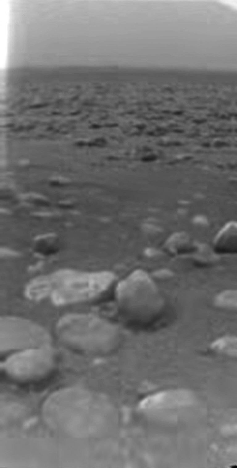
There's less signs of vegetation, but a leptocottus armatus* swam through.

The solid parts of my scenes don't move, whereas either what Huygens landed on undulates and flexes gently in the waves or there were some hefty heat waves making it appear so. (Not impossible - after all, Huygens was hot after it entered the atmosphere, and it had heaters on board.)

Notwithstanding the differences, a similar general impression of wavering of the features under the motions of very shallow liquid is obtained in both animations. The submerged foreground features are less clear than the not submerged ones behind and there are some reflections towards the far side.

*aka Pacific sculpin, bullhead

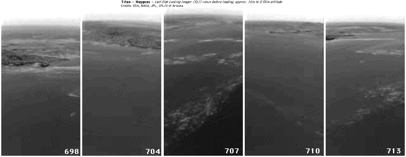
Note: An animation of the MRI and HRI images after landing is visually less interesting than the SLI. However, something happens to the window of the MRI 3 or 4 times, each time shrinking the bright blob on the lower right. Hit by waves perhaps? And twice droplets of liquid can be seen which drip off (or otherwise disappear). The HRI lens window appears to get hit by something once, much changing the view. If they are submerged, these events may be occurring on the insides of the windows via leaks. (If Huygens is on dry ground, what is happening?)

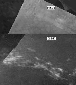
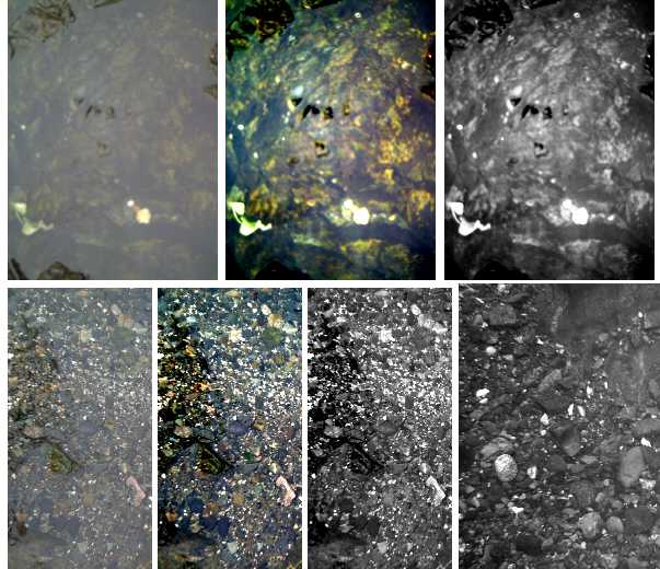
In this final "Huygens anniversary images" installment, here are three shots of shallow liquid from above, simulating, albeit on a tiny scale, the sort of view angles of Huygens's HRI imager during the descent.

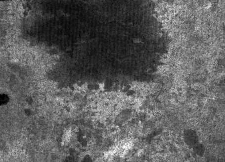
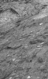
The triply processed images show that while the liquid is plainly there in the original color shots, it becomes less evident if the contrast is increased, and almost invisible if made monochrome. With the Huygens shots, we only have the latter. In the bottom right image, the waterline is visible, but tracing its course, and recognizing that's what it is without first suspecting liquid, might be tricky.

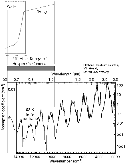
The reader will please forgive me for hammering pretty hard on these visual points as people continue to believe that Titan's seas are dry, largely through non recognition of the ubiquitous liquid in the Huygens images.

Idle Speculations on the ACCELEROMETER DATA AT LANDING
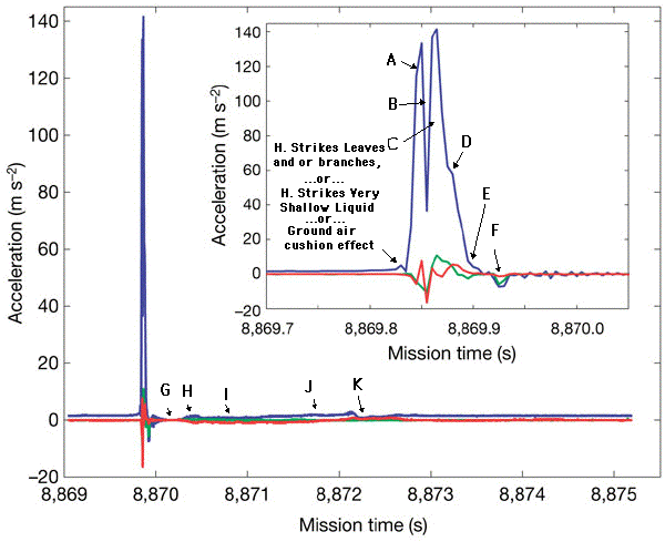
 
 
"Additionally, the area of [un]stable data points immediately following the initial impact (8,870.1 - 8,870.3 s) may be due to a small bounce of the probe or to some structure vibrations." (http://www.nature.com/nature/journal/v438/n7069/fig_tab/nature04314_F9.html)
 
This is the sort of finding I was expecting, after hearing of the gentle "creme brulee" landing.
 

I am beginning to view the landing area (if not the whole world) as a saturated bog of organic sludge that has built up by the tide flows to virtually the surface level at many points, with the flow then channeling mainly through deeper areas. (The Louisiana wetlands comes to mind.) Given the expectation of atmospheric haze particles drifting down to the surface from the upper atmosphere, such an organic sludge could perhaps exist even if there was no life on Titan.
Both ACC-I and the (parallel) HASI ACC PZR X sensor registered a small precursor peak of a few meters per second squared in amplitude. One possibility is that it may be due to impact of the probe's foredome with an isolated protuberance such as an "ice cobble"; resting on the surface."
This gentle deceleration that "gradually" built up from zero just before the probe actually struck the ground may be due to the foredome striking the very shallow liquid methane on the surface, whose depth can thus be estimated (very, very approximately) as:
 

height of liquid = time of transit (initial small deceleration reading until strong solid impact reading)  *  velocity
= .01 to .015 seconds * 4.60 meters/second
= .046 to .069 meters or 4.6 to 6.9 cm - 2 or 3 inches.
Of course, with such shallow liquid, one spot might be twice as deep as another right next to it, depending on the texture of the surface, so a precise result is perhaps somewhat academic. The reading could perhaps also be explained by a cushion of stiff leaves just above ground level. Both leaves (not, I believe, ice cobbles) and liquid seem evident in the surface animations. However, either way, one wouldn't really expect the force to taper off again as it does before the main impact.
In a possible "bounce" after the impact, a surprising negative G force of short duration is seen at one point, actually stronger than Titan's gravity, as if somehow, the surface had got a grip on Huygens and wouldn't let it bounce up. This could be explained by something holding the penetrometer from rising (seems unlikely), or general momentary suction from liquid or saturated sludge as Huygens tried to lift out in a bounce (more likely). However, this bounce, and another major difference, was measured by just one of two accelerometers (ACC PZR-X). The other (ACC-I) claimed there was no bounce at all.

(These differences should warn us that interpretation of individual instrument readings, like individual "face on Mars" scenes in an image, are not infallible. If either accelerometer had not been present, the other would probably have been taken as being definitive. Of course, I'm thinking of the SSP results, some of which are said to "conclusively" rule out liquid, somewhat at odds with the GCMS surface liquid findings as well as the liquid visible in the images - as plainly as contrast enhanced monochrome images can show it. And (ahem) some of my own earlier Huygens image feature interpretations. But I digress.)

The timing of almost three seconds from initial impact to stability of readings, as well as the gentleness of the forces, is indicative of a landing on a surface that was by no means solid (like sand with rocks or mud or clay), but rather something having some definite, if small, elastic aspect to it that rebounded and appeared to cause sideways motion as well. A soil of marine 'sludge' could perhaps cause this result. An interesting experiment might be to take a "Huygens" equivalent and drop it with equivalent force here onto various surfaces and see what would cause similar readings, including peat bogs and shallow swamps. The seeming surface undulations over time visible in the animations were not detected by the accelerometers, so either these were gentle in the extreme and hence the feeble readings were hidden in random background noise, or perhaps they were "mirage" heat waves caused by Huygens itself and not real motion. The instruments were sensitive enough to tentatively detect a gradual change in tilt of Huygens of about 1/2 a degree over the 70 minutes of transmission and to suggest that Titan's radius may be 3Km greater than the published figure of 2575Km.

 
My comments on statements about the landing site, taken from various news clippings [immediately after the landing].
"When the probe landed, it was not with a thud, or a splash, but a 'splat'. It landed in Titanian 'mud'. I think the biggest surprise is that we survived landing and that we lasted so long," said DISR team member Charles See. There wasn't even a glitch at impact. That landing was a lot friendlier than we had anticipated,"
The term "splat" is based on the accelerometer readings. This is not inconsistent with the very shallow liquid seen in the view from the ground. So splat yes, mud no. The landing was cushioned by the belly hitting a few inches of liquid methane, probably about the same time as the 12 cm accelerometer probe struck the stone and then sliced into the sand or gravel as elsewhere stated.

 
"In addition to the soft landing, material that appears to have accumulated on the camera lens in the final images suggests the weight of the 705 pound probe may have pulled it into the muddy surface."


It looks more like something was in front of the lens and has partly moved aside in the later images.
 

"The closest analogs are wet sand or clay,"
Being underwater, it's bound to be wet. Since it's rocky and since the tide probably rips by here about 6 days out of 16, sand seems more likely than clay.
 

[About the audio] "Further processing could make the data sound more like what we might hear if we were riding along with Huygens. This sort of work requires some assumptions, some guesses, and sometimes a little artistic license."
The rushing, being a rather steady-state noise (and *seemingly* too loud to be internal mic hiss), may actually be the flow of the tide.


=====

Huygens SSP Readings (July 2006

I have wished to discuss in detail the Huygens Surface Science Package (SSP) instrument readings as related to the question of whether Huygens landed in very shallow liquid as seems visually evident, or on dry ground. However, so far (July 2006), I have been unable to locate any information about the actual readings of several sensors.

[Note july 10th: It seems the SSP data will be released in September 2006 at ESA's Planetary Science Archive, http://www.rssd.esa.int/psa .]

Certain of the instrument readings which were specifically cited to me as indicating a dry landing would actually have been similar or identical to the readings which would have accompanied the shallow liquid landing. In deeper liquid, with Huygens floating, the results would have been markedly different.

Additionally, the fact that Huygens is looking at shallow liquid does not necessarily indicate that Huygens itself is immersed in that liquid, even though it makes it likely. Huygens could have struck the edge of a beach and be on "dry" ground looking towards the 'water', or it could be propped up above the shallow liquid by objects on the ground, of which some are in view in the after landing images, including something evidently touching the HRI and MRI windows which moves a couple of times after the landing. And there are several possible situations each individual instrument could have found itself in after a landing in shallow liquid:

a) recessed inside the foredome, it could have remained just above liquid and continued to read Titan's air.
b) it could be immersed in clear and relatively pure liquid.
c) it could be immersed in muddy or otherwise impure liquid within the 'top hat'.
d) it could be in solid contact with the ground, under liquid or not.
e) it could be buried in mud that oozed its way into the 'top hat' during or following the impact.
f) there could be one or more surface obstacles inside the 'top hat' interfering with instruments such as the refraction and accoustic sensors. (Perhaps similar to the one blocking the views of the MRI and HRI imagers)

I will go into as much detail as seems useful here about each instrument, as far as it is known to me:

Accelerometer & Penetrometer

Graphs of these readings have been published, and much can be said and speculated on from these.

The "creme brulee" soft landing is more indicative of a muddy surface with a major liquid component (and no rocks) than of dry ground. There are two special puzzles in the readings. The first is the initial penetrometer reading of a "crust" or "pebble". (I hate to bring life into this chapter, but... it seems more likely it punched through a leaf or branch, but whatever it was it was not the main finding.) The second odd reading was a negative G force soon afer the impact, greater than Titan's (or even Earth's) gravity. This seems to me to indicate that when Huygens landed, perhaps having compressed some springy material, it tried to bounce up but was held down, probably by suction, to the extent that a discrepancy of readings between the SSP and another accelerometer indicates there was probably some internal flexing inside Huygens. For about 1/2 a second, the nature of Titan's ground seems to have had more effect on Huygens movements than gravity had. Liquid is much more likely to have such effects than dry ground.

Another interesting point is that the liquid did not appear to be muddy in the photos taken soon after the landing, so if Huygens impact stirred up much mud, it settled or was washed away surprisingly quickly. (I wish I knew how soon after the landing the first ground image, 723, was taken.) Yet, there appears to be some liquid and probably a bit of mud splattered on the SLI view window after landing.

Conclusion: Except for the initial penetrometer spike, the accelerometer data strongly supports the landing on very soft ground in shallow liquid. A varying surface layer of living or dead organic debris is possible, showing up on the penetrometer as a "crust", making the surface "springy", and preventing the mud beneath from clouding the liquid, an effect which we might expect from the disturbance of Huygens' landing.

Tilt Sensor

The tilt of the probe after landing (and not floating) is not very relevent to whether the landing was dry or wet.

Conclusion: the tilt sensor neither supports nor negates either a wet or dry landing.

Accoustic Sensors - Dx to Surface, Rate of Descent, Surface Roughness (eg due to waves), speed of sound (as yet unpublished).

While it will be interesting to know the readings obtained for the speed of sound before and after landing, the multiple scenarios quoted above show that it could have read almost anything without disproving the shallow liquid landing.

Conclusion: Whatever the readings of the accoustic sensors, they cannot be taken as definitive evidence for either a dry or liquid landing.

RADAR

Since Huygens wasn't floating, the return pulses from the immediate surface at centimetric distances would overlap the send pulses and nothing could be seen.

Conclusion: The RADAR instrument readings had nothing to say about whether the landing was wet or dry.

SONAR

As with the RADAR, it would seem that the SONAR pulses, meant to read multiple meters of liquid depth, would not have been able to separate the send pulse from the receive at centimetric distances.

Conclusion: The SONAR instrument readings had nothing to say about whether the landing was wet or dry.

Index of Refraction

As with the accoustic sensor, again we have various possible scenarios for the situation of the refractive index sensor after landing. In air, the reading wouldn't vary from in the descent data, in methane it should have read 1.27, while in mud there should have been no reading. And again what was read has yet to be released.

Conclusion: Air refractive readings, or no reading, from the refraction measuring device can't be taken as proof of a dry landing, while a reading in the 1.27 range would definitely support the shallow liquid landing.

Temperature

Since Titan's temperature is fairly constant 384 hours a day, little or no difference in temperature between air, liquid and ground would be expected.

Conclusion: The temperature provides little evidence for any particular landing scenario.

Thermal Conductivity

Again we have several plausible after-landing scenarios for the situation of the thermal conductivity unit (readings not yet released). If it was immersed in liquid or mud, the thermal conductivity should should have been different than in air.

Conclusion: Since we can't say for sure whether it was in air, liquid or mud, the thermal conductivity doesn't rule out the shallow liquid in the view.

Heat Capacity

Heat capacity (readings not yet released) would be much greater either in the under'water' soil or in liquid than in air. As with several other underside sensors, no reading would exclude the shallow liquid in the view.

Conclusion: The heat capacity readings can't refute the shallow liquid landing, still less if they don't read that they're still in air.

Dielectric Constant

Electrical capacitance in liquid or in mud saturated in non-polar liquid would be much higher than in air. But again, we don't know the situation of the sensors after the landing, and again the readings haven't been released.

Conclusion: Some readings might tend to support the shallow liquid in the view, but no readings would refute it.

Whatever the SSP readings, they should be balanced against the facts that the downward looking spectrum from 21 meters using Huyens' broad spectrum light source looked like methane, and that "Upon impact the GCMS inlet was heated, and a surge in the methane mixing ratio was recorded, indicating a reservoir of liquid methane on the surface." ...and that's not to mention the apparent liquid the images.

The balance of the instrumental evidence and the images falls heavily on the side of a landing in very shallow methane.

 
1st draft: May 3rd, 2005
Rewritten: August 3rd 2005
Rev: August 22 2005
Rev: August 24 2005 (Press statement about GCMS surface findings incorporated)
Rev Aug 27 2005 (added "Sprays" image)
Rev Oct 4 2005 (minor wording edit)
Rev Nov 15 2005 (Better figures for tidal "heads" lead to some reworking of tide description; removed some refs to "rocks" where Huygens landed since that's not what they are.)
Rev Jan 13-15 2006 (My new "Huygens Anniversary" landing site image mosaic, replacing DISR's "Very_Low_Level_Mosaic"; Comparison of Earth water motions shown in animations vis-a-vis Titan liquid methane motions shown in t2.mov (or better, my new TitansSurfaceAnimation.GIF). Comparison of Earth water and Titan liquid methane in downward looking still images.)
Rev Jan 20 2006 (Added extra notes on my mosaic, "Match the images" idea, and a note about the possible "waterline" on the SLI lens window. A brief look at accelerometer data from the landing.)
Rev Feb 5th 2006 (Added calculation of shallow liquid depth at landing site by accelerometer readings & revised the accelerometer text.)
Rev March 8, 2006 (New "closest up" downward looking mosaic shows Huygens landed on a small brighter "island" within the dark area, not on the dark area itself per se. I also went through much of the text and did a general edit here and there, in keeping with my feeling that titan (at least the landing area) is like a giant bog of organic sludge built up to the surface in many areas in a shallow sea. The liquid of that sea races back and forth through deeper channels with the once per day tides.)
Rev March 14 2006 (Added lowest altitude SLI images below the mosaic for a broader perspective of the landing area.)
Rev April 27th 2006 (Added a New landing point mosaic that I think is more correct; notes about downward looking spectrum from 21 meters indicating methane surface.)
Rev July 08 2006 (Added image/diagram pointing out feature correspondences between high altitude HRI images and lower level SLI images. Re-worked text for reconciling SSP data with shallow liquid landing. Added a note on atmospheric tides. Added paragraph on "cat scratches" as probably being huge waves on the seas.)
Rev July 28 2006 (New improved close up mosaic of the landing area; new findings on Cassini radar and Huygens radio signals as concerns liquid methane. (the "cat scratches" may be submerged terrain!)
Rev April 2007 (Revised explanation of the tides and a link to a more detailed new explanation in chapter three.)
Rev Jan. 2023 (Many details changed/added as I quickly run through the file & locate the images, for upload to the new web site. TurquoiseEnergy.neocities.org )

New email:

craigxc      Craig Carmichael
@post   Victoria BC Canada -- (Moved to Haid Gwaii May 2017)
.com      250 384 2626


Images are from the Huygens Titan Lander or the Cassini Spacecraft, or are multi-image "mosaics" composed of these images, unless otherwise indicated. Image credits unless otherwise stated go to those involved with the mission: ESA, the Italian Space Agency, JPL, NASA and the DISR (Descent Imager and Spectral Radiometer) team, University of Arizona.

(See Living Titan index for general links)